


Thunderstorms
You'll
either love it or hate it, whatever the case may be it certainly gets your
attention.
(An extract from a mail I wrote about it)
The
initial breakdown in the weather came on Tuesday the 11th of July (it had been
exceptionally dry here for 7 weeks or so preceding- an official drought).
At
The
lightening was all ctg (fork). There was, at one point, strikes every 0.5
seconds. Most of the strikes I witnessed were around the Cambusnethan, Coltness
area. The rain fell at an intensity I've never witnessed before and since.
Within half an hour I had to rush out into the monsoon like rain, to empty my
old rain gauge (75mm). Whilst doing this a fork of lightening crossed the sky directly
over my head, the thunder was instantaneous, cracking first in my left ear then
my right. It was like a bomb exploding the noise was so deafening. I guess the
bolt could only have been 25m or so above me (nearly sizzled to death).
Only
3/4 of an hour after the storm started the clouds were breaking, the storm petered
out by around
That
morning (
I
could barely believe it, here was a possible tornado spawner right before my
very eyes. Action would be fast and furious so I had to quickly get to a
position to witness this monster. Bad mistake!! At
There
was a strike every two seconds for around two or three hours. The direction
that seemed to get the worst of it was the Ravenscraig site. By
That
was that, no Tornado chasing for me. We got out the car and headed for Tesco in
a hurry, the water was shin deep rushing down the street. When we got to the
entrance of the shop the electric doors were closed and I later found out this
was because the shop had a power-cut, part of the roof had collapsed due to the
weight of water that had accumulated, this shorted all the power. We abandoned
all hope and headed into the Commercial bar for a pint or two until the worst
was over. It was
The
stats. bore out that I collected 84.2mm of precipitation that day, but I know there
must have been a few areas locally with much more than that, It's a pity no-one
had a rain gauge underneath it. The flash floods that day will go into history
for this area due to their severity. There were confirmed reports of a small
tornado in Bothwell (7 miles west) that afternoon, it was said to have touched
down for around 20 seconds, twisting some small trees to pieces and then
launching a kids small play chute 40ft in the air. The
---------------------------------------------------------------------------
Intense lightning storm
This was a short lived affair, though very
intense for this location. I had noticed around
---------------------------------------------------------------------------
Electrical skies
This storm kicked of pretty much at
By
Between
In total I must have witnessed or heard far
more than 1000 lightning strikes within those four hours. The rain total from
the storm wasn't so exceptional at around 32mm - however, a mere mile or two to
the South of this location the story was completely different......
..... Wishaw town centre, Pather, Overtown,
---------------------------------------------------------------------------
Fast charging clouds
I'm beginning to think that the Wishaw area is
Picture it; A beautifully warm Monday,
the first truly warm day of the year. Those fortunate enough to have the day
off from work (like myself) are basking in the garden. The temperature climbs
up to 22.2ºC in a near cloudless sky. Ten minutes later some cumulus blot out
the sun, ten minutes later again and the cumulus are towering many thousands of
feet toward the stratosphere. Before your very eyes huge anvils are forming, it's
a sure fire thunderstorm in the making. indeed, not one cell, but multiple - or
was it just one MCS (meso-scale convective system)?
This was to be yet another afternoon
to remember. At around
In one hour from
---------------------------------------------------------------------------
Firstly, on May 4th. Around 8pm a band of thundery weather made its way through the central lowlands, centred to the west of Wishaw. The storms lasted for the next 3 hours and ravaged parts of Glasgow and it's suburbs. Lightning rates were again very high with spectacular forks every other second for a sustained period. Because it coincided with the onset of nightfall, the lightning was all the more vivid. And a times had a pink hue from my vantage point. Flash floods were seen in some local areas. Particularly in the northern suburbs of Glasgow. As far as Wishaw was concerned, this was a near miss, but exciting light show. At the time I was on the phone to my partner Andy who, excitedly from the doors of a pub in Glasgow city centre, described how the city was being demented with thunder and lightning and how the train service - his means home - was interrupted by flooding.
The first week of July was notably thundery also, with cells passing overhead on a few mornings. None very spectacular though. The afternoon of the 5th was very warm and humid and some major storms developed over the southern uplands and moved into the eastern half of the central lowlands. Impressive skies looking South and east from Wishaw, but no cigar here apart from a short burst of torrential rain and the odd distant rumble.
---------------------------------------------------------------------------
A pub quiz rainstorm 3rd July, 2008
Four weeks earlier on the 5th June, I was doing my usual Thursday night thing. Which generally involves rushing home from work in order to make it on time for a quiz night at a bar in Wishaw. On that occasion my attention was distracted somewhat by a Thunderstorm rumbling away outside, the lightning was all sheet and it was still daylight, so no great show. Exactly 4 weeks later, same location but more fierce results.
Firstly have a look at the picture I took on my mobile phone, from the door step of the Commercial hotel in Wishaw, looking down Marshall street. It was taken about 10 minutes before the storm kicked off - behold the gathering storm!
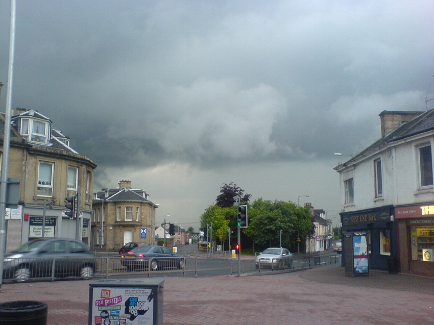
The lightning came hard and fast just before 9.30pm. All of it blinding forks striking various parts of Wishaw. This continued for 10 minutes, and I was rather enthralled watching from my vantage point beneath the awnings of the Commercial hotel. It then started to rain, well - for a few seconds - and then what can only be described as the ocean emptying above our heads commenced. Me and my friend Andrea cowered beneath the awning as the rain tore down... The 3 meter dash to the entrance of the bar seemed a mile away, and in the brief second or two it would take us to reach the shelter of the pub we would clearly get utterly soaked. Flash, bang - gee that was close!
Now the rain is as heavy as any rainstorm I've ever witnessed - echoes of 1995 indeed. I'm in virtually the same place! One minute after the rain had started the air was already filled with spray. Along comes a freak gust of wind and pours the contents of the awning right on top of me, Andrea and some other unlucky fella. Ok, time to go indoors now lol! Drenched! A couple of minutes to compose myself and then back to the door with another fellow quiz team member; Mark... And wow, Wishaw main street river has returned with a vengeance. And it's running right past the door of the bar - we're stuck. And even at the door we're getting soaked again from the spray. Let's head back in and tell the others. FLASH/BANG (Mark scream's lol)- I think that was damn close, the new TESCO building probably. 150 meters away. Get me a drink!
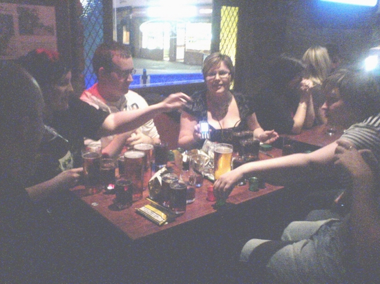
A few moments later, the river is in full spate, my fellow quiz team members are having a paper boat race at the door of the bar :-) But the quiz is about to start and the rain seems to be passed it's worst. Back to our table we go. I'm watching out the window for a while at the occasional bright flashes from outside, not really concentrating on the quiz. It's still a river outside and down the road. Next thing two fellow members of the quiz team arrive, oh dear oh dear. They look like they've just gone for a swim fully clothed. Not one piece of them is remotely dry. Clothes weigh a tonne. Nikki and Alan had decided to walk it to the pub from Coltness and had got caught in the height of the storm. The rain had came on so fast and heavy there was no point in them heading for shelter on route.
A mile further north at my site, I was shocked to discover later that only 6mm of rain had fallen into the gauge. Clearly it was a small, but nasty cell. I'd estimate in central Wishaw half an inch of rain (12.5mm) fell in little over 20 minutes. Glasgow road was cut off by a flash flood right outside Chapmans butcher shop, well actually it was flooded inside too, as were the other businesses beside it. (You can see this area on the picture above to the right hand side). Stupidly I never took any photo's of the aftermath Duh! Netherton in Wishaw was completely cut off for some time by the flash floods, no roads in were passable. And many a drain had popped during the storm due to pressure from the sheer volume of water below, an added hazard for drivers.
The storm headed off into the night as darkness fell...And me and my fellow team-mates; we won the quiz that night and thoroughly enjoyed the £50 drink voucher. ;-)
---------------------------------------------------------------------------
Of
course there have been other storms here besides, but none quite match up to
some of those above. Those were foreigners, not supposed to happen in this country. Roll
on the next occasion; nothing quite matches the majesty of a severe and close
thunderstorm.